Guide to Aurora Sentry Data
This guide is an unofficial collection of notes on the use of data used in Aurora Sentry. In no way should this be considered a substitute for official information from the scientists and organizations providing the data. Please check the web sites of the providers for official information. The title above each real time data image is a link to the originating web page.
This document is a work in progress. Updates will be made at irregular intervals.
Definition of Terms
Poleward? Equatorward? North? South? Arrgh!!
Oval Estimates
NOAA NGDC Ovation Prime North Nowcast
NOAA NGDC Ovation Prime North Forecast
NOAA POES Statistical Auroral Activty (North)
NOAA POES Statistical Auroral Activity (South)
STD Visible Auroral Oval
Magnetometers
North America: Boulder, Colorado
North America: Fredericksburg, Virginia
North America: Newport, Washington
North America: College, Alaska
North America: San Juan, Puerto Rico
North America: Tucson, Arizona
Pacific region: Learmonth, Australia
Pacific region: Canberra, Australia
Pacific region: Honolulu, Hawaii
Pacific region: Guam
Solar wind and Dst Index
SEC Solar Wind Dials
UC Berkeley Dst Index
Costello Predicted Kp Index
ACE MAG and SWEPAM
SRI Dst Index and Solar Wind
SoHO Proton Monitor
Solar Activty, etc.
GOES Xray Flux
GOES Satellite Environment
SoHO EIT 195 Å
GOES Solar X-ray Imager
Definition of Terms
Poleward and Equatorward
When discussing aurora, and dealing with northern and southern hemispheres (users of this site come from all over the globe) the terms north and south can be confusing. What we usually want to know is whether some location is closer to the [north or south] pole than another, or whether some location is closer to the equator than another. Therefore we use the terms poleward and equatorward. Poleward means "closer to the pole" (north in the northern hemisphere, south in the southern hemisphere). Equatorward means "closer to the equator" (just the opposite of poleward).
Oval Estimates
Oval Estimates attempt to provide an overall visual indication of the extent of the auroral oval(s) plotted on a map in near real time. Aurora Sentry displays this page by default.
NOAA NGDC Ovation Prime North Nowcast
This is a real time nowcast model of auroral power. The plot shows intensity (color scale) and position of the auroral oval. Local noon is always at the top of the plot, local midnight at the bottom. Thus the top half of the plot represents areas currently in daylight, the bottom half in darkness. The model uses solar wind data from the ACE spacecraft as input.
NOAA NGDC Ovation Prime North Forecast
This is a forecast model of auroral power. The forecast valid time may be anywhere from several minutes to more than an hour into the future depending on solar wind speed. The time interval is shown on the plot. The plot shows intensity (color scale) and position of the auroral oval. Local noon is always at the top of the plot, local midnight at the bottom. Thus the top half of the plot represents areas currently in daylight, the bottom half in darkness. The model uses solar wind data from the ACE spacecraft as input.
NOAA POES Statistical Auroral Activity (North)
A statistical estimate of the position of the northern auroral oval based on data from the NOAA POES satellite. Intensity of auroral activity is rated on a scal of 1 to 10. Generally very high values (9 or 10) would indicate aurora in the northern continental U.S. Tends to lag real time somewhat.
NOAA POES Statistical Auroral Activity (South)
A statistical estimate of the position of the southern auroral oval based on data from the NOAA POES satellite. Intensity of auroral activity is rated on a scal of 1 to 10. Tends to lag real time somewhat.
STD Visible Auroral Oval
Based on data from the NOAA POES satellite, this plot is intended as a guide to where the aurora should be visible. This tends to lag real time to some extent. The color changes from green through brown and eventually to red as the aurora intensifies. Aurora is most likely to be visible within the shaded areas near the equatorward boundary of the auroral region.
Magnetometers
Magnetometers displayed in Aurora Sentry are ground-based instruments which measure fluctuations in the Earth's magnetic field. Most magnetometers are three axis instruments, measuring the direction and intensity of the magnetic field. Two common coordinate systems are in use: H, D, I (where H=horizontal intensity, D=Declination, I=inclination) and X,Y,Z (where X=horizontal northward, Y=horizontal eastward, Z=vertical downward). From these measurements, the local K index can be computed. For the average amateur radio aurora enthusiast or visual aurora observer, experience is probably the best way to correlate magnetometer data with local auroral activity. It is suggested to choose the magnetometer closest to the observer's location. Minor fluctuations in the magnetic field components occur constantly, but significant aurora events will be marked by much larger deviations. With experience, it is possible to quite accurately determine when to start (or stop) looking for aurora based on magnetometer data. Following is a list of magentometers currently displayed by Aurora Sentry:
North America: Boulder, Colorado
North America: Fredericksburg, Virginia
North America: Newport, Washington
North America: College, Alaska
North America: San Juan, Puerto Rico
North America: Tucson, Arizona
Pacific region: Learmonth, Australia
Pacific region: Canberra, Australia
Pacific region: Honolulu, Hawaii
Pacific region: Guam
Solar Wind and Dst Index
Our sun is a hot and stormy place. It continuously emits a stream of fast moving inoized gas (plasma) called the solar wind which flows out through the solar system. This solar wind also has magnetic fields contained within it. Events on the sun control the "strength" of the solar wind. Coronal holes cause the wind to escape the sun at a higher than normal velocity. Coronal mass ejections often accompany strong flares (and other solar events), and these can cause drastic disruptions in the solar wind. The solar wind is always interacting with Earth's magnetic field, and these interactions change during times of disturbed conditions, causing what is known as a geomagnetic storm on Earth.
The data in this section is based on measurements by satellites located in line between the sun and Earth (but much closer to us than to the sun). From here we can get a near real time indication of what is happening in the solar wind as it approaches Earth. Because these satellites are located some distance from our planet, we see the conditions in that part
of the solar wind that is 30 to 60 minutes away from Earth. This can be very important, giving a warning when conditions on Earth are about to change. Some Aurora Sentry users watch this page almost exclusively during storm times in order to have a feel for what is about to happen with the aurora.
Several properties of the solar wind are measured. Among the most important for our purposes are the speed of the solar wind (in kilometers per second), its ion density, and most important the magnitude and orientation of magnetic fields within the solar wind. "Southward oriented" magnetic fields in the solar wind interact with Earth's magnetic field much more than neutral or northward oriented fields.
Some caution is in order when using data based on measurements from the ACE satellite. During some storm times, protons hurled into space from powerful solar flares may interfere with the instruments' ability to provide meaningful data. If the ACE-based data seems to indicate "all quiet" while other data is indicating storm conditions, this may be the cause.
SEC Solar Wind Dials
Using data from the ACE spacecraft, these dials show the most important measured parameters: magnetic Bz component (strength of the magnetic field in the north-south direction), speed, and dynamic pressure. Note the color coding on the dials; as the pointers move more toward the red portion of the scales, the chances of geomagnetic storming (and aurora) increase. Most important of all here is the Bz, which really needs to be southward (-) to produce storm conditions on Earth. The dials are very convenient, but show only an instantaneous "sample" of solar wind condtions. Current trends are best observed using some of the other data in this section.
UC Berkeley Dst Index
Computed from ACE data, this is a convenient dial that gives the current near real time Dst estimate. Yellow indicates mild storm, red is strong storm conditions. Dst is an index that monitors the worldwide magnetic storm level. Negative values of Dst indicate a storm in progress (only negative values shown on this dial). The actual Dst index is computed from many
magnetograms from ground based instruments around the world. The data provided here is an estimate of what that Dst index will be based on measurements of the solar wind.
Costello Predicted Kp Index
Based on ACE data, this is a computation of the predicted Kp index. The blue line shows actual observed Kp. This source is very useful for seeing recent conditions at a glance, with an estimate of short-term future trends as well.
ACE MAG and SWEPAM
This is the "raw" data from ACE. It is very good for observing both short term fluctuations and long term trends. The white Bt trace in the top panel is the total field strength (total intensity) of magnetic fields in the solar wind, while the red Bz trace is
the magnetic field intensity in the very important north-south direction. Bt (and often Bz) increase during storm times. Sustained southward Bz will be necessary to produce geomagnetic storming and aurora for all but the most poleward locations. Density and speed are also important parameters. In particular, a sudden increase of 50 units or more in speed probably
indicates arrival of a shock front ahead of a disturbance. It is important to note the main phase of the disturbance is often several hours behind the shock front.
SRI Dst Index and Solar Wind
This is another useful plot based on ACE data which color codes the very important Bz parameter: green when there is little or no chance of significant storming; yellow for slight or moderate chance; red for strong chance of storming. From the raw data, current Dst estimate and storm conditions are computed.
SoHO Proton Monitor
This is the one item in this section that is not based on data from ACE. Instead this one uses solar wind measurements from the SoHO spacecraft, which is not subject to "blackouts" from proton contamination. The top two traces (solar wind speed and density) show very clearly when a disturbance has arrived.
Solar Activity, etc.
Solar activity is what drives the solar wind, and disturbances in the solar wind drive geomagnetic storms. It is therefore a good idea to keep an eye on potential storm-inducing events on the sun. Such events would include coronal mass ejectioons or CMEs (which often occur in conjunction with major solar flares) and coronal holes. It takes 1 to 4 days for
a disturbance to transit from sun to Earth in the solar wind.
GOES Xray Flux
From the GOES satellites, this is a near real time measurement of solar radiation in the form of X-rays. Solar flares are readily apparent as spikes in the plot, but it is important to remember that not all flares are associated with a CME. Solar flares are classified according to their peak intensity and fall into "bins" of C, M, or X class. "Major flares" are those reaching M5 or higher. Caution must be used here, but typically a flare associated with a large CME will have a very rapid rise, slow decay signature. CMEs can and do occur when there is no flare and little or no X-ray signature is apparent. In addition, many large CMEs which will show up in X-ray data are not "aimed" at Earth and will have little or no impact on conditions here. Still, this is a very useful chart that shows when conditions are getting stormy on the sun.
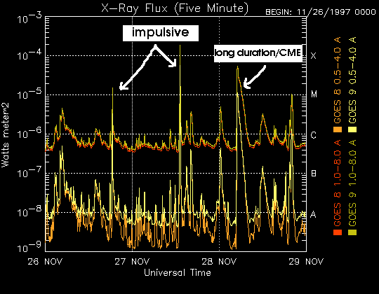 Examples of impulsive flares (usually not associated with a large CME) and a long duration flare. The long duration flares with this type X-ray signature are often accompanied by CMEs capable of producing geomagnetic storms.
|
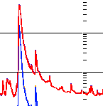 Typical X-ray signature of a long duration flare associated with a CME. A severe geomagnetic storm arrived only one day after this powerful X class event.
|
GOES Satellite Environment
Several useful measurements of the near-Eath space environment are made by the GOES satellites. The top panel (Proton flux) is a measurement of energetic protons, usally associated with poweful solar flares. Proton levels here will be elevated (generally above the dashed line) at times when the ACE sensors (see Solar Wind section of this document) are experiencing "proton contamination". The third panel (Hp) is from the onboard magnetometer and wild fluctuations occur during geomagnetic storms. The bottom panel shows the Kp index color coded green (quiet or unsettled), yellow (active) and red (storm).
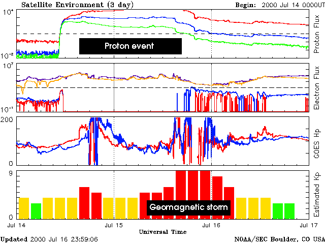 GOES satellite environment plot during storm time. Notice the proton event (top panel). ACE sensors were adversely affected by this event. A severe geomagnetic storm peaked late on July 15.
|
SoHO EIT 195 Å
A usfeul image of the sun from the Extreme Ultraviolet Imager on the SoHO spacecraft. At this particular wavelength (195 angstroms), coronal holes appear as dark (black) areas. Coronal holes near the sun's polar regions (top and bottom of the image) have little impact on conditions at Earth, but holes that traverse the center of the image near the solar equator can cause the solar wind speed to increase, sometimes dramatically. Coronal holes are long duration features which will be observed to move across the image as the sun rotates on its axis, appearing in the east (left) and rotating toward the west (right). As a coronal hole passes the center of the solar disc, the solar wind streaming out through it is aimed toward Earth; the maximum affect will be observed 2 to 4 days after the hole passes the center of the image, due to transit time from sun to Earth. Solar active regions (typically associated with groups of sunspots) appear as bright areas.
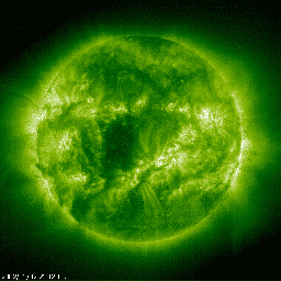 EIT 195 Å image showing a coronal hole approaching the central meridian. Three to four days later solar wind speed increased to around 600 km/s and the geomagnetic field was at active to minor storm levels
|
GOES Solar X-ray Imager
This image from the GOES-14 satellite shows solar radiation in the form of X-rays. The bright areas are "bright" in X-rays, usually associated with active sunspot groups. If major flares occur while the larger, more intensely active regions traverse the center of the solar disc (facing Earth), the chance of a disturbance reaching Earth increases.